Charter activations
索马里的洪水
数周的暴雨导致索马里发生大面积洪灾。 据估计,洪水已经影响了50万人。
下雨导致谢贝利河和朱巴河淹没了他们的河岸,洪水泛滥。 超过20万人被迫撤离。 洪水影响了哈撒贝乐,朱巴兰和西南部州。 据报道,索马里国家安全部队疏散了1万多人,他们被哈撒贝乐州贝莱特韦内肆虐的洪水所淹没。
正在建立紧急定居点以向受害者倾斜,但有人担心,获得清洁水的机会有限会带来水传播疾病的风险。
| 事件类型: | 洪水 |
| 事件地点: | 索马里 |
| 启动宪章的日期: | 2018年5月7日 |
| 宪章启动时间: | 16:01 |
| 宪章启动时区: | UTC+02:00 |
| 宪章要求者: | 训研所 - 联合国组织卫星组织代表联合国人道主义事务协调厅 |
| 启动ID: | 570 |
| 项目经理: | UNITAR / UNOSAT |
Products

Situation report of flooding in Shebelle River, Southern Somalia
版权: © CNES (2018) - Distribution: Airbus Defence and Space, all rights reserved
Download full report
Information about the Product
已获得: 15/05/2018
源: Pleiades

Situation report of flooding in Juba River, Southern Somalia
版权: Pleiades © CNES (2018) - Distribution: Airbus Defence and Space, all rights reserved
Download full report
Information about the Product
已获得: 14/05/2018
源: Pleiades

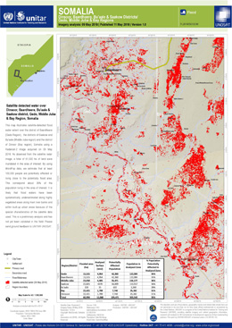
Flood detection in Dinsoor, Baardheere, Bu'aale, Saakow district, Gedo, Middle Juba and Bay Region, Somalia
版权: RADARSAT-2 Data and Products © Maxar Technologies Ltd. (2018) - All Rights Reserved. RADARSAT is an official trademark of the Canadian Space Agency.
Map produced by UNITAR / UNOSAT
Information about the Product
已获得: 09/05/2018
源: RADARSAT-2

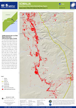
Flood detection in Belet Weyne and Bulo Burto Districts, Somalia
版权: RADARSAT-2 Data and Products © Maxar Technologies Ltd. (2018) - All Rights Reserved. RADARSAT is an official trademark of the Canadian Space Agency.
Map produced by UNITAR / UNOSAT
Information about the Product
已获得: 09/05/2018
源: RADARSAT-2
 返回完整的响应档案

 English
 Spanish
 French
 Chinese
 Russian
 Portuguese


