Charter activations
哥伦比亚洪水
2017年4月1日,大雨造成哥伦比亚的三条河流决堤。洪水冲入莫科阿市,泥土和泥石流涌向街道,将整个社区夷为平地。
莫科阿市位于安第斯山脉脚下的哥伦比亚南部。该地区的多山地形使得山体滑坡成为一个寻常事件,但灾害对莫科阿的破坏已经被描述为这个城市有史以来最糟糕的事件。城市的大部分地方都被洪水携带的泥土、岩石和树木所覆盖。
该城市已经宣布进入紧急状态,目前正在进行搜救工作,以找到埋在泥土和瓦砾之下的幸存者。尚有200多人失踪,500多人无家可归,但哥伦比亚总统宣布了一项承诺,帮助受灾的所有人员重建被毁的城市。
| 事件类型: | 洪水 |
| 事件地点: | 哥伦比亚 |
| 启动宪章的日期: | 2017年4月01日 |
| 宪章启动时间: | 19:30:00 |
| 宪章启动时区: | UTC+02:00 |
| 宪章要求者: | 国家灾害风险管理单位(UNGRD)/国家灾害风险管理单位,哥伦比亚环境研究所 |
| 启动ID: | 524 |
| 项目经理: | ESA(欧洲航天局) |
Products
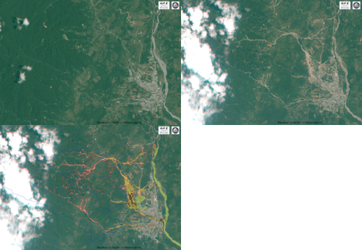
Animation of Landslide and Debris Flow Detection in Mocoa
版权: RapidEye data © Planet Labs Inc. (2017) - All rights reserved
Map produced by Remote Sensing Section, Helmholtz Centre Potsdam - GFZ German Research Centre for Geosciences
Information about the Product
已获得: Before-image: 21/11/2013
After-image: 10/04/2017
源: RapidEye
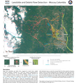
Automated landslide and debris flow detection in Mocoa
Download a PDF version of this map
版权: RapidEye data © Planet Labs Inc. (2017) - All rights reserved
Map produced by Remote Sensing Section, Helmholtz Centre Potsdam - GFZ German Research Centre for Geosciences
Information about the Product
已获得: Before-image: 21/11/2013
After-image: 10/04/2017
源: RapidEye
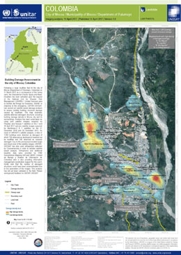
Damage assessment of buildings in Mocoa
版权: Pleiades © CNES (2017) - Distribution: Airbus Defence and Space, all rights reserved
GeoEye-1, WorldView-1 and WorldView-2 © DigitalGlobe Inc.
Map produced by UNITAR/UNOSAT
Information about the Product
已获得: Pleiades: 07/04/2017 and 10/04/2017
GeoEye-1: 10/04/2017
WorldView-1: 26/12/2013
WorldView-2: 21/12/2016
源: Pleiades / GeoEye-1 / WorldView-1 and -2
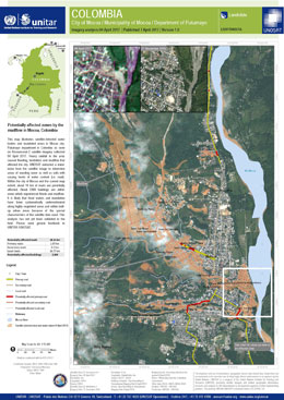
Areas potentially affected by the mudflow in Mocoa
版权: ResourceSat-2 data and products © ISRO (2017) - All rights reserved
WorldView-3 © DigitalGlobe Inc.
Map produced by UNITAR/UNOSAT
Information about the Product
已获得: ResourceSat-2: 04/04/2017
WorldView-2: 21/12/2016
源: ResourceSat-2 / WorldView-2
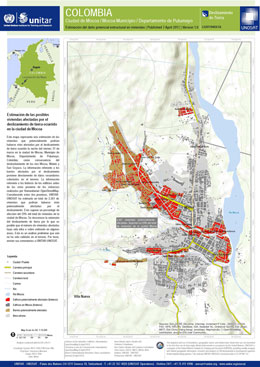
Estimated damage to buildings in Mocoa following the landslide
版权: Map produced by UNITAR/UNOSAT
Information about the Product
已获得: 06/04/2017
源: OpenStreetMap & Humanitarian Mapping Unit and ground data from authorities
 返回完整的响应档案

 English
 Spanish
 French
 Chinese
 Russian
 Portuguese


