Charter activations
Hurricane Maria in the Dominican Republic
Hurricane Maria brought heavy rain and strong winds to the Dominican Republic as it continued its course through the Caribbean. The storm passed by the northeast coast of the Dominican Republic at Category Three strength, and caused flooding and landslides.
As it struck the eastern parts of the Dominican Republic the storm was at Category Three strength.
At least two people were killed and it is estimated that 110 homes were destroyed by the storm and hundreds more suffered at least some damage. 10,000 people were forced to evacuate their homes and many of those are currently housed in emergency shelters.
| Тип события: | Ocean Storm - Hurricane |
| Место события: | Dominican Republic |
| Date of Charter Activation: | 2017-09-19 |
| Время активации Хартии: | 11:00 |
| TЧасовой пояс в районе активации Хартии: | UTC+02:00 |
| Запрос на активацию поступил от: | Comisión Nacional de Emergencias CNE |
| Номер активации: | 556 |
| Менеждер проекта от: | Equipo Interinstitucional de Información Geoespacial (EIGEO) |
Products

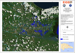
Areas flooded in Bajo Yuna
Авторские права: RADARSAT-2 Data and Products © MacDonald, Dettwiler and Associates Ltd. (2017) - All Rights Reserved. RADARSAT is an official trademark of the Canadian Space Agency.
Map produced by EIGEO
Information about the Product
Получено: 26/09/2017
Источник: RADARSAT-2

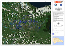
Areas flooded in Bajo Yuna
Авторские права: RADARSAT-2 Data and Products © MacDonald, Dettwiler and Associates Ltd. (2017) - All Rights Reserved. RADARSAT is an official trademark of the Canadian Space Agency.
Map produced by EIGEO
Information about the Product
Получено: 24/09/2017
Источник: RADARSAT-2
 Вернуться к полному архиву активаций

 English
 Spanish
 French
 Chinese
 Russian
 Portuguese


