Charter activations
Floods in Türkiye
Heavy rains over the Marmara Region affected the districts of Silivri, Catalca, B. Cekmece, K. Cekmece and Bakirkoy in Istanbul. By the afternoon of 9 September, 31 casualties were reported, along with missing people.
| Tipo de evento: | Floods |
| Local do evento: | Türkiye |
| Data da Ativação da Carta: | 10/09/2009 |
| Requisitante da Carta: | Ministry of Public Works and Settlement - General Directorate of Disaster Affairs, Türkiye |
| Gerenciamento de projeto: | CNES in collaboration with the SAFER project in the framework of the GMES initiative |
Products

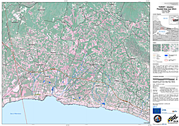
Satellite map of the flooded area around Silivri west of Istanbul, Türkiye, of September 12, 2009
Direitos autorais: CNES 2007, German Aerospace Center (DLR) 2009
Canadian Space Agency 1999
Image processing, map created 13/09/2009 by ZKI © DLR 2009
Information about the Product
Adquirida: 12/09/2009, 19/08/2009 and 07/07/2007
Fonte: TerraSAR-X, RADARSAT-1 and SPOT-5

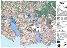
Satellite map of the flooded area west of Istanbul, Türkiye, of September 11, 2009
Direitos autorais: CNES 2007; German Aerospace Center (DLR) 2009;
Canadian Space Agency 1999 and 2009
Image processing, map created 12/09/2009 by ZKI © DLR 2009
Information about the Product
Adquirida: 19 and 22/08/1999; 11/09/2009; 3/03/2009; 11/09/2009 and 7/07/2007
Fonte: Radarsat-1; Radarsat-2; TerraSAR-X and SPOT-5
 Voltar ao arquivo completo da Ativação

 English
 Spanish
 French
 Chinese
 Russian
 Portuguese


